下载APP

【简答题】

(24分)读下图:我国部分地区某河流河谷及其某月气温分布图,结合所学知识,回答下列问题。
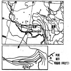 (1)图中方框区是世界著名的雅鲁藏布大峡谷,分析该峡谷的形成原因。(6分) (2)图中等温线为该区域________月(1月,7月)等温线分布状况,说明判断理由并分析①②间等温线弯曲的原因。(12分) (3)分析该地区主要的能源资源。(6分)


参考答案:

参考解析:


刷刷题刷刷变学霸
举一反三
【单选题】一定量的理想气体,分别经历如图(1)所示的a b c 过程(图中虚线ac为等温线),如图(2)所示的d e f过程(图中虚线d f为绝热线)。判断这两种过程是吸热还是放热:
A.
a b c过程吸热,d e f过程放热
B.
a b c过程放热,d e f过程吸热
C.
a b c过程和d e f 过程都吸热
D.
a b c过程和d e f过程都放热
【单选题】The Grand Canyon Standing on the rim of the Grand Canyon(大峡谷), gazing across this giant wound in the Earth’’s surface, a visitor might assume that the canyon had been caused by some ancient convulsion...
A.
Astronomy
B.
Botany(植物学)
C.
Geology
D.
Chemistry
【单选题】The Grand Canyon Standing on the rim of the Grand Canyon(大峡谷), gazing across this giant wound in the Earth’’s surface, a visitor might assume that the canyon had been caused by some ancient convulsion...
A.
it was caused by some ancient convulsion
B.
its presence is an embarrassment to the state of Colorado
C.
it looks like an injury on the Earth’s surface
D.
it has caused many visitors to injure themselves